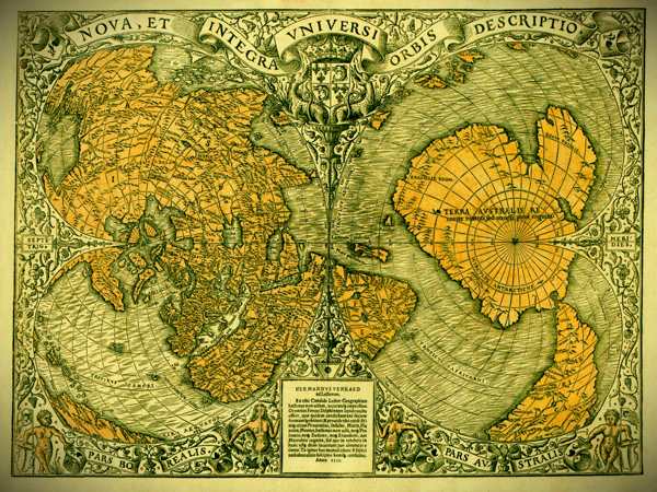
The Oronteus Finaeus map, discovered in 1960 by Charles Hapgood, has become a cornerstone of fringe history and a source of fascination for explorers of the unknown. Drawn in 1531, it depicts a continent strikingly similar to Antarctica – ice-free, with flowing rivers and mountain ranges. This has fueled speculation about lost civilizations and advanced knowledge possessed by ancient cartographers.
But what’s the truth behind this intriguing map?
Intriguing Similarities:
The Finaeus map shares some undeniable similarities with modern maps of Antarctica. The continent’s overall shape aligns somewhat, and features like the Ross Sea are vaguely recognizable. This has led some to believe the map portrays a pre-glacial Antarctica, a landmass free from ice thousands of years ago.
However, closer scrutiny reveals significant discrepancies. The coastline on the Finaeus map deviates considerably from Antarctica’s actual shape. Additionally, the map lacks details about the vast interior, which many believe would have been ice-covered at the time.

Questionable Accuracy:
Despite claims of superior accuracy, the Finaeus map exhibits limitations. It likely relied on earlier maps and geographical theories, not actual exploration of Antarctica. It shows other continents with inaccuracies, indicating a lack of precise geographical knowledge in the 16th century.
The Hapgood Effect:
Hapgood, a proponent of ancient advanced civilizations, may have overstated the map’s accuracy. Some believe he manipulated the map slightly, adjusting coastlines to better resemble present-day Antarctica. This raises questions about the objectivity of his analysis.
Science Steps In:
Scientific evidence provides a different perspective. Core samples taken from the Ross Sea in 1949 revealed layers of sediment, suggesting environmental changes. While some layers show evidence of rivers, this doesn’t necessarily confirm a completely ice-free past. Antarctica’s climate has fluctuated over time, with periods of glacial retreat.
The Mystery Remains:
While the Finaeus map might not depict a pre-glacial Antarctica, it remains an intriguing historical artifact. It reflects the cartographic knowledge of the 16th century and hints at the evolving understanding of our planet.
The question of how Finaeus achieved some level of accuracy in depicting Antarctica remains unanswered. It could be a result of compiling existing knowledge, including possible ancient Greek or Phoenician voyages (though evidence is scarce).
The Takeaway:
The Oronteus Finaeus map is a reminder of the ongoing quest to understand Earth’s history. While it may not be a definitive map of pre-glacial Antarctica, it continues to spark debate and ignite the imagination. The truth likely lies somewhere between a lost civilization and mere cartographic coincidence. Further research and exploration may someday provide more definitive answers.

