
Ghost Towns of Nevada
Nevada provides especially fertile ground for studying ghost towns, as the hot desert air has preserved even many 100-year-old wooden buildings, and many of the ghosts in Nevada remain in isolated solitude (unlike, say, Colorado, where former ghost towns are now ski resorts).
I’ve concentrated primarily on the “true” ghost towns in this study—towns or mining camps that are completely deserted. A few of the towns have a handful of people living in them, but never more than a few dozen. Towns such as Tonopah, Hawthorne, or Virginia City—with populations in the hundreds and operating casinos—are better classified as historic towns and do not appear in this study.
With the exception of the towns near Death Valley, all of the photos in this essay were taken in the 1985–1991 time frame. Since then, I’m sure that some of the buildings pictured within have disappeared, or in some cases (Gold Point, Belmont), have been restored to full use. Consider these photos to be a snapshot in time.
Throughout this study, I have used a personal rating system (0 being very low and 10 being very high) to rank three categories in each ghost town. These include:
REMAINS: What is the quantity and quality of remaining boom-era structures in the town or area?
Accessibility: How easy is it to get to the site?
Exploring: How accessible are the buildings in the town? Are there interesting back roads to drive down? Posted “No Trespassing” areas are rated low; open areas in national forests are rated high.
1. Aurora
| Founded: | 1860 |
| Population: | 1861: 2,000 1863: 10,000 1991: 0 (Active mining operations) |
| Mining type: | Gold, silver |
| Location: | 23 miles SW of Hawthorne (Mineral County) |
| Remains: | 2 |
| Accessibility: | 4 |
| Exploring: | 1 (Active mining operations) |
Background:
Aurora, founded in 1860 when gold and silver were discovered there, has had almost as many lives as a cat. The initial boom, which lasted until 1869, yielded close to $30,000,000 in ore. A second and smaller boom lasted from the late 1870s to 1882. The town was rejuvenated again in the early 1900s and served several hundred people through World War I. By 1919, Aurora was pretty much dead. In 1946, most of the buildings in the town were levelled for their bricks. There is almost nothing left of the original town now.
Aurora was a rough camp located near the California/Nevada border.Prior to 1863, the border was disputed, and Aurora citizens voted in elections for both California and Nevada! (This was remedied in 1863, when a survey indicated that Aurora was really in Nevada.) At its peak in the 1860s, Aurora had 16 mills, 21 saloons, 12 hotels, and two newspapers. (A later newspaper was named, amusingly enough, the Aurora Borealis.) Mark Twain (Samuel Clemens) worked in Aurora for a short time in 1862 as a miner and laborer.
Aurora will probably always be connected with nearby Bodie, California. A tortuous 15-mile mining road connects the two town sites. At the Aurora end, there are large signs that state encouraging things like “Road to Bodie closed” and “Four-wheel drive vehicles only; enter at your own risk.” You can imagine my shock when a Toyota Corolla came barreling out of Bodie Road in front of me when I was on the way to Aurora. The driver stopped me to ask for directions, and I said to him, “You came from Bodie in THAT?” He answered, “Yeah, but I’ll never do it again!”
Aurora is once again an active mining area. A group called the Aurora Partnership is conducting strip-mining operations on the once deserted site.
What is left to see is stone rubble.

2. Belleville
| Founded/abandoned: | 1873/1892 |
| Population: | 1876: 400; 1882: 500; 1985: 0 |
| Mining type: | Silver mill |
| Location: | 9 miles SW of US 95 on SR 360 (Mineral County) |
| Remains: | 2 |
| Accessibility: | 10 |
| Exploring: | 10 |
Background:
Belleville flourished in the late 19th century as a mill site for the nearby mines in Candelaria. It was also the terminus of the Carson and Colorado Railroad, which reached there in 1882. Belleville declined after 1887, when a water pipeline was constructed to Candelaria.
What is left to see:
stone walls and basement depressions.

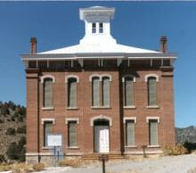
3. Belmont
| Founded: | 1865 |
| Population: | 1868: 2000 |
| Mining type: | Silver |
| Location: | On SR 82, between U.S. 50 & U.S. 6 (Nye County) |
| Remains: | 10 |
| Accessibility: | 7 |
| Exploring: | 5 (much is private property) |
Background:
Belmont is one of the more substantial ghost towns in Nevada, as many of the stores, mills, and public buildings were made out of stone or brick, including the magnificent 1876 Nye County Courthouse. Belmont served as the county seat from 1867 to 1905. Most of the major mines were closed by 1890, although there was a brief revival during World War I.
What is left to see:
The courthouse has been restored by the state of Nevada. Various interesting ruins dot the area, including storefronts and a smokestack from the Monitor-Belmont mill. The photos were taken in 1985, when Belmont was pretty much deserted. In recent years, several businesses have opened that cater to the tourist trade.

.jpg "28 Nevada Ghost Towns and Historic Towns 4")


4. Berlin
| Founded: | 1895 |
| Population: | 1905: 250 |
| Mining type: | Silver |
| Location: | Several miles E of SR 844 (Nye County) |
| Remains: | 10 |
| Accessibility: | 7 |
| Exploring: | 8 (state property, but open to the public) |
Background:
The Berlin operations lasted from 1895 to just before World War I, with the peak being around 1905-1912.Berlin briefly had a post office and a store.
What is left to see:
Berlin is part of a Nevada State Park, and new roofs have been put on some of the ruins to arrest further decay. An old mill is virtually intact, although the interior was stripped during World War II. Several other buildings are intact, and pieces of machinery can be seen scattered around the area.


5. Bonnie Claire
| Founded: | 1904 (Thorp); renamed Bonnie Claire in 1906 |
| Population: | 1907: 100 |
| Ghost town type: | Ghost of it’s former self |
| Mining type: | Gold milling; railroad center; later, lead smelting |
| Location: | About 20 miles NE of Scotty’s Castle |
| Remains: | 10 |
| Accessibility: | 10 |
| Exploring: | 0 (private property) |
Background
- station on the Bullfrog & Goldfield and Las Vegas & Tonopah railroads (1906–1928). Tracks were torn up, and the post office closed in 1931.
- Shipping centre during construction of Scotty’s Castle in the 1920sFrom 1935 to 1953, the Lippincott Smelter smelted lead ore from the Lippincott mine.
What’s left to see
Significant Lippincott Smelter ruins (posted private property)
.jpg "28 Nevada Ghost Towns and Historic Towns 11")
6. Broken Hills
| Founded: | 1913 |
| Population: | 1914/18: several hundred |
| Mining type: | Silver |
| Location: | About 20 miles SE of U.S. 50, off of SR 361 (Mineral County) |
| Remains: | 4 |
| Accessibility: | 5 |
| Exploring: | 10 |
Background
The Broken Hills area was productive from 1913 to World War II, with the World War One era being the glory days for the town itself.
What’s left to see
A mine lift mechanism, and a lonely grave. Photos from 1985.


7. Candelaria
| Founded: | 1863 |
| Population: | c. 1880: 1,500 |
| Mining type: | Silver |
| Location: | Midway between US 95 & SR 360 on a dirt road (Mineral County) |
| Remains: | 5 |
| Accessibility: | 5 |
| Exploring: | 5 (active mining operations) |
Background
Candelaria had a reputation for being one of the toughest camps in the West. It boasted 27 saloons and no church at it’s peak in the 1880s. The town contained both silver mines and mills, and produced over one million dollars a year for the decade following 1875. A fire destroyed much of the town in 1883, and the town declined after 1885. After a brief post-World War One revival, Candeleria was deserted until the recent revival (see below).
What’s left to see
A strange site greets the visitor to Candelaria. As one rounds the bend in road, the site of the old main street of the town comes into view. And in the background is the largest (1985) functioning silver mine in the World (Candelaria Mining Company – Nerco).
There are several wood/dugout buildings left on the hillside, and some traces of the mills are left. Two stone front stores peer at each other from the opposite sides of the graded dirt road. The old cemetery is right against the Nerco operation, and has been well preserved, with a metal fence around it. It was nice to see that a modern day mining company could be good stewards of our nations history.


8. Carrara
| Founded: | 1904 (town site – 1913) |
| Ghost town type: | Dead |
| Mining type: | Marble |
| Location: | About 10 miles E of the eastern border of Death Valley. Near Beatty, Nevada |
| Remains: | 8 |
| Accessibility: | 10 |
| Exploring: | 8 |
Background
Marble quarrying began in the area as early as 1904, with a town site dedicated in 1913. The Post Office closed in 1924. In 1936, a cement company built several buildings near the old town site, but never began operations.
What is left to see:
Ruins of several large, stone buildings (associated with the 1936 cement company).

9. Daveytown
| Founded: | 1910 |
| Mining type: | Gold, silver |
| Location: | 40 miles northwest of Winnemuca (11 miles southwest of SR 140) (Humboldt County) |
| Remains: | 6 |
| Accessibility: | 4 |
| Exploring: | 10 |
Background
Daveytown was a late addition to mining activity in the Slumbering Hills area of Humboldt County. Operations in this area began in 1910, and continued on and off until 1951. One area mine, the Jumbo, was once owned by Texas tycoon H. L. Hunt. Herbert Hoover visited the area in 1936, bringing the Jumbo mine nationwide publicity.
What’s left to see
There are several wooden and metal buildings left, plus the remains of a small ore loading facility, and some old, rusted out automobiles.


10. Dun Glen (Chafee)
| Founded: | 1862 |
| Population: | 1863: 250 1880: 50 1908: 1000 (Chafey) 1991: 0 |
| Mining type: | Silver |
| Location: | 9 miles NE of Mill City (Pershing County) |
| Remains: | 1 |
| Accessibility: | 2 |
| Exploring: | 10 |
Background:
Dun Glen, founded in 1862, had three mills by the 1870s. In 1863, and 1865, a small army garrison was stationed in the town to protect the miners from Indians. By 1894, the area was pretty much deserted. A larger town was built on the spot in 1908, named Chafey, when new ore discoveries were made. In 1913, operations at Chafey ceased.
What is left to see:
Dun Glen is a very pretty setting, marked by some large trees. However, nothing is left except some stone foundations, and some tailings from later mining operations. Probably not worth the 9 mile trip on a dirt road!
.jpg "28 Nevada Ghost Towns and Historic Towns 19")
11. Gold Canyon (Comstock Lode)
| Founded: | 1849 or 1852 |
| Mining type: | Silver, gold |
| Location: | SR 341 & SR 342, about 20 miles SE of Reno (Storey County) |
| Remains: | 10 |
| Accessibility: | 10 |
| Exploring: | 5 (much is private property, but much is open to the public) |
Background:
The Comstock Lode, which runs underneath the 7-mile long Gold Canyon, is the richest silver find in the history of the world. A sign in Virginia City states “rocks that produced 1,000,000,000 in gold and silver”.
Although there are varying reports of small finds in the area dating as far back as 1849, the real discovery and development of the Comstock Lode began in 1859. A second major boom began in the 1870s, when the population of the major town on the Comstock, Virginia City, reached over 25,000 (making it the largest town in the West at that time). The other towns in Gold Canyon, Silver City (population 1,200 in 1861) and Gold Hill (population 8,000in 1873) were also significant population centers. Major mining continued on the Comstock until the late 1930s.
Even today, the Comstock is probably still the richest silver deposit in the world. However, most of the 600 miles of mine tunnels under Gold Canyon are flooded with water, and it is estimated that to pump it out would take a repository the size of Lake Tahoe!
What is left to see:
Gold Canyon probably has the largest concentration of “ghost” mines and mills of any comparable-sized area in the world. The three aforementioned towns are still occupied, with Virginia City(1991 population: 700) being a significant tourist attraction. In addition to the mine ruins in Gold Canyon, Virginia City has many 19th-century buildings, including three significant churches, a vibrant main street area, and an opera house.
In the following photos, I’ve concentrated on the ghost mines. The photos were taken at various times between 1985 and 1991


12. Gold Point
| Founded: | 1868 |
| Mining type: | Lime, Silver, Gold |
| Location: | 14 miles SW of intersection of U.S. 95 & SR 266 (Esmeralda County) |
| Remains: | 10 |
| Accessibility: | 8 |
| Exploring: | 8 (private, but open to the public) |
Background
Gold Point has had three different names in its history, each in reference to the type of mineral being mined. Originally christened Lime Point (1868), it later changed to Hornsilver (1908) and Gold Point (1930). The latter is the name it still bears today. At one point, New York Giants (baseball) owner Charles Stoneham owned the largest mine in the area, the Great Western.
Major mining operations stopped here during World War II, and by the 1960s, Gold Point was pretty much abandoned. In recent years, many of the buildings have been restored, and a bed and breakfast operates here in several of the restored cabins.
What is left to see
There are 40+ buildings still standing here, many of them restored (see above). Many mine hoist mechanisms dot the surrounding countryside. The photos below are from 1985, when the restoration was just beginning.


13. Grantsville
| Founded: | 1863 |
| Population: | 1879: 800 |
| Mining type: | Silver, gold |
| Location: | 5 miles SW of Berlin (Nye County) |
| Remains: | 10 |
| Accessibility: | 5 |
| Exploring: | 10 |
Background
Grantsville at its peak was much larger than the better-known Berlin, boasting 10+ stores, 12 saloons and a population of 800/1000 in 1879. The town was pretty history by 1885, but mining has continued off and on as recently as World War II.
What’s left to see
There is a fairly well preserved mill (probably c. World War II), several buildings (including one of the original stone buildings from the 19th century), a graveyard and a corral.


14. Humboldt City
| Founded: | 1860 |
| Population: | 1863: 500 |
| Mining type: | Silver |
| Location: | About 4 miles east of 1-80, halfway between Lovelock and Winnemucca, Nevada (Pershing County) |
| Remains: | 8 |
| Accessibility: | 7 |
| Exploring: | 10 |
Background
Humboldt City is one of those strange ghost towns in Nevada that have an exit off of I-80. The Humboldt exit of I-80 takes one to a trailer park. To get to the ghost town, an additional 4.5-mile trek is necessary, first, along an un-maintained state road that parallels I-80, and then on a winding, one-lane mining road that heads straight into the Humboldt range. Once in the completely deserted Humboldt City, there is a stunning view of the Rye Patch Reservoir to the west (see first photo).
At its peak in the 1860s, Humboldt City had over 200 hundred buildings. Over 1,000 silver discoveries were made in the Humboldt City area, before its abandonment in 1869.
What is left to see
Remains of about 20 buildings. I suspect that some of these are from a later date than the 19th century, and perhaps have been used as hunting shacks.


15. Lower Rochester
| Founded: | Early 1860s/1912 |
| Population: | 1913: 2200 (includes Rochester) |
| Mining type: | Silver, gold |
| Location: | 22 miles NE of Lovelock (Pershing County) |
| Remains: | 8 |
| Accessibility: | 8 |
| Exploring: | 10 |
Background:
See Rochester.
What is left to see:
Several mining buildings and lift mechanisms are intact


16. Manhattan
| Founded: | 1867 |
| Population: | 1906: 4,000 1985: 28 |
| Mining type: | Gold, silver, copper |
| Location: | About midway between SR 376 and SR 82, SW of Belmont (Nye County) |
| Remains: | 10 |
| Accessibility: | 6 |
| Exploring: | 6 (some posted private property) |
Background:
Although a small amount of mining was done in the area as early as 1867, Manhattan’s heyday started around 1905, when a post office opened, and the population swelled to 4,000 within a year. Large-scale mining operations continued into the early 1950s, including a dredging operation that started in 1938.
As of 1985, Tenneco had started up mining operations in the area.
What’s left to see:
Several wooden buildings, the remains of a stone bank, lots of mine rubble, and a wooden church that once stood in Belmont.


17. Millers
| Founded: | c. 1865 (Desert Wells) |
| Population: | c. 1910: 250 |
| Mining type: | Silver mill |
| Location: | 15 miles W of Tonopah |
| Remains: | 5 |
| Accessibility: | 10 |
| Exploring: | 10 |
Background
You have to look hard to find Millers these days, but 85 years ago it had a railroad repair yard, silver mill, and cyanide plant. Originally a desert oasis named “Desert Wells” (c. 1865), the town blossomed in 1904 when the Tonopah railroad located a repair yard here, and the name was changed to Millers (after a mining official).
It looked like Millers was going to experiencing a revitalization in the early 1980’s, when the Anaconda company started up mining operations in the nearby mountains, but they have since been terminated, leaving old Millers in its serene state of decay.
What’s left to see
Today there is a state highway rest area there (complete with several displays of local history), and the concrete remains of the old cyanide plant. A dugout house remains among the rubble, with a bed still inside – not very comfortable lodgings!

18. Pine Grove
| Founded: | 1866 |
| Population: | 1868: 200; 1875: 600 |
| Mining type: | Gold |
| Location: | 30 miles S of Yerington (Lyon County) |
| Remains: | 7 |
| Accessibility: | 2 |
| Exploring: | 10 |
Background:
Pine Grove is your classic Nevada ghost town. Founded after the Civil War; had a post office, newspaper and several mills; decline in the late 19th century; revival in the 1960s.
I’ll claim a special affinity for Pine Grove, as it was my first Nevada ghost town.
What is left to see:
There are two pretty much intact buildings (assumedly dating to the 1960s revival) left in this isolated, eerie ghost camp. The view is quite spectacular, particularly if one is hardy enough to climb up one of the canyon sides. Pine Grove is part of the Toiyabe National Forest.


19. Quartz Mountain
| Founded: | 1920 (site) |
| Population: | 1926: several hundred |
| Mining type: | Silver-lead |
| Location: | 2 miles east of Broken Hills (Nye County) |
| Remains: | 3 |
| Accessibility: | 3 |
| Exploring: | 10 |
Background:
After initial discoveries in 1920, Quartz Mountain bloomed in 1926, and a small town was built (with buildings being moved in from Rawhide and Goldfield). The town had almost died out by 1927.
What is left to see:
A mine hoist and an outhouse. Photo from 1985.

20. Rawhide
| Founded: | 1906 |
| Population: | 1908: 8,000/10,000 |
| Mining type: | Gold |
| Location: | 4 miles W of SR 31, 19 miles S of U.S. 50 (Mineral County) |
| Remains: | 3 |
| Accessibility: | 5 |
| Exploring: | 5 |
Background
At its peak in 1908, Rawhide was actually larger than the more famous Rhyolite. On Sept. 4, 1908 tragedy struck – a fire wiped out most of the town, and it was never rebuilt.
What’s left to see
The 1908 fire, the elements, and active mining operations have pretty much decimated Rawhide, with the only prominent ruins being that of a stone jail.


21. Rhodes
| Founded: | 1862 (Post Office 1893) |
| Mining type: | Salt, borax |
| Location: | Near the intersection of U.S. 95 & SR 360 (Mineral County) |
| Remains: | 3 |
| Accessibility: | 10 |
| Exploring: | 10 |
Background:
Rhodes served as a salt distribution center for the Hawthorne/ Comstock/Tonopah mining areas (nearby is a large salt marsh). Camels were utilized to transport salt to the Comstock.
Rhodes was also a station on the Carson and Colorado Railroad. The Post Office closed in 1911.
What is left to see:
Rubble, and the remains of a lone salt loading tower.

22. Rhyolite
| Founded/abandoned: | 1905/1922 |
| Population: | 1907: 6,000 1910: 675 1922: 1 |
| Mining type: | Gold (3.1 million dollars from 12 mines) |
| Location: | 1.5 miles N of Rt. 374, near Beatty, NV |
| Remains: | 10 |
| Accessibility: | 9 |
| Exploring | 7 |
Background:
Rhyolite is one of the most famous ghost towns in the old west, because of the large number of extant buildings. Gold was originally discovered in the area by famous Death Valley prospector Frank “Shorty” Harris in 1904. By 1907, there were four newspapers, three railroads, as well as a number of profitable mines and mills (one owned by Charles Schwab). The financial panic of 1907 caused the boom town to go bust.
What is left to see:
Several streets are fairly intact, and there are impressive remains of a bank, school, jail, retail store, and the Las Vegas & Tonopah Railroad station. Also, the famous 1906 bottle house, made out of thousands of beer and champagne bottles can be seen here.


23. Rochester
| Founded: | 1860s/1912 |
| Population: | 1913: 2200 (includes Lower Rochester) 1991: 0 |
| Location: | 22 miles NE of Lovelock (Pershing County) |
| Remains: | 8 |
| Accessibility: | 8 |
| Exploring | 10 |
Background:
Rochester Canyon was named in the early 1860s by, you guessed, people from Rochester, New York. The town wasn’t established until 1912, though, when rich silver discoveries were made. Rochester had a number of buildings, two newspapers, and its own Philharmonic Orchestra. Heavy mining operations continued into the 1920s, but the area was pretty much deserted by 1942.
Rochester and Lower Rochester (about a mile away from each other) are both fairly easy to get to, and boast a number of intact buildings. Both are located about 9 miles east of the Oreana exit of 1-80. Helpfully, the exit signs on I-80 indicate the name Rochester, but you are on your own finding it after exiting I-80.
What is left to see:
Rochester has several standing wooden buildings (probably dwellings), as well as an intact mill.


24. Rockland
| Founded/abandoned: | 1868 |
| Population: | 1870: 150 |
| Mining type: | Gold |
| Location: | 20 miles south of Yerington (near Pine Grove) (Lyon County) |
| Remains: | 8 |
| Accessibility: | 2 |
| Exploring | 10 |
Background:
Rockland is located about 15 miles from the nearest paved road, but the last 5 miles of that trip will put one on one of the worst mining roads that I have personally ever been on. Don’t even DREAM of making the trip unless you are in a truck of some kind – I punctured an oil pan in a car on this very road in 1985!
Rockland had several lives. The first strikes were made in 1868, as an extension to nearby Pine Grove. By 1872, the Post Office was closed, and the town went into decline. By Worid War I, though, the town had been revived, and stayed in operation until 1934. Operations began again in 1969, but Rockland is once again silent.
What is left to see:
Several wooden buildings left, and some breathtaking views.


25. Scossa
| Founded: | 1907 |
| Mining type: | Gold |
| Location: | 46 miles N-NW of Lovelock (Pershing County) |
| Remains: | 5 |
| Accessibility: | 4 |
| Exploring | 5 |
Background
Scossa was established in its first iteration in 1907, when “jewelry gold” was found in the Antelope Range. After existing for several months, Scossa was abandoned until large gold strikes were made in 1931. For the next several years, Scossa was among Nevada’s largest producers of gold. In 1937, the town died for good.
Scossa is a good 30 miles from the nearest paved road.
What’s left to see
A well-kept building that may be inhabited. One source describes it as a former saloon, and another as the former drug store. There are also some wooden shacks, and lift mechanisms high on the hills overlooking Scossa to the east.


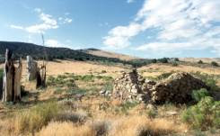
26. Star City
| Founded: | 1861 |
| Population: | 1864: 1200 1871: 78 |
| Mining type: | Silver |
| Location: | About 40 miles SW of Winnemucca (Pershing County) |
| Remains: | 2 |
| Accessibility: | 4 |
| Exploring | 10 |
Background:
Star City was founded in 1861 when rich silver strikes were made in the area. For a brief time, it was the largest city in Pershing County. At its high point in the mid-1860s, Star City had 7 large mining companies active in the area, and a 10 stamp mill. By 1880, Star City was merely a memory.
What is left to see:
There is almost nothing left of Star City except two lift mechanisms, a lonely grave, several stone ruins, and some stunning scenery

27. Vernon
| Founded: | 1905 |
| Population: | 1907: 300 |
| Mining type: | Gold |
| Location: | 26 miles NW of Lovelock (Pershing County) |
| Remains: | 2 |
| Accessibility: | 3 |
| Exploring: | 10 |
Background
Vernon is a long way from anywhere. A narrow paved road leads the first 14 miles from Lovelock to Vernon (built for the nearby Eagle Pitcher Mine), and the last 12 miles is on dirt roads. For several years starting in 1905, Vernon was the center of the Seven Troughs district. Its glory days were over by 1910, though, and the post office was closed in 1918. Most of the buildings were moved to nearby Tunnel in the 1920s.
What’s left to see
The only extant building is the stone remains of the two-cell jail. Local lore reports that the jail was still impregnable in the mid-1960s, until some vandals blew it up.

28. Weeks
| Founded/abandoned: | 1859 (Buckland) |
| Location: | Near Ft. Churchill (Lyon County) |
| Remains: | 5 |
| Accessibility: | 10 |
| Exploring | 2 |
Background:
Weeks has had several names and functions in its 100+ year history. While it enjoyed a short mining boom in the early 1900s, its original raison d’etre was as a supply point for nearby Fort Churchill, and as a stopover point for people on the way to the Comstock Lode. Weeks was originally named Buckland after its founder.
What is left to see:

The original roadhouse still stands, as well as several smaller buildings, nestled in a scenic grove of trees.